Showing posts with label Map. Show all posts

Friday, 11 March 2011

A Car Dominated Town

Mapped cars at high season in town centre. 
Designated car parks highlighted in red.

Sunday, 20 February 2011

Friday, 11 February 2011

AD 2100 'Isle of Bognor'

Conservative predictions for sea level rise due to the melting of the arctic ice cap are for around 7ft by 2100. 


Thursday, 20 January 2011

Bognor by the Sea

Bognor is situated on the south coast of England. A town of 65,000 people it is a place with a number of dislocated communities. Self contained systems exist creating towns within a town. Exploring Bognor as an organism will help my understanding of what flows in and out of the town and activates the communities. As mentioned earlier on this blog Butlin's holiday camp will be a focal point for my continued research into possible future scenarios for the town. Like the Vatican or the Kremlin it has distinct boundaries and a number of separation devices are utilised to maintain autonomy. Walls, money, tickets, windows and gates are some examples that should be understood when thinking about the towns relationship with Butlin's.
Two photographs show the frontage the holiday resort has with the town. A car park lines the beach front and public promenade.


Tuesday, 30 November 2010

Water Infrastructures 워터 인프라

Water flows through the city, pipes pierce the ground and buildings and supply the citizens needs. The map studies the differing infrastructures that collect, store and transport water. At street level this movement is recorded and metered via small devices attached to the exterior of buildings. This is another key characteristic of the traditional fabric and one that the Apatu complexes lack. 

Friday, 26 November 2010

A Complete Strategy is needed 전략

Comments from my tutorial with Professor Mull. All stronger and clearer now, looking for a way of doing things, making connections. emulsify? Emulsion has a different quality to it, putting something into a liquid condition, a different conceptual starting point? Little doors interesting, natural tendency is to open things up visually and physically. Connection can become a constricting relationship so that is more intriguing as there is the whole riverside of views and connections. Interesting, emulsion and little doors, a more complex, narnia version of connection. The gift project will have to tackle all these boundaries. Sequence of spatial interventions. Concentrate less of drumming up programme, more about different spatial conditions across rift from inland to the river. Taken as a whole can be a whole vocabulary. Similar linear structure, of filmic moments along this, but not in 3d yet. Don't come back with another project that looks at hangang regeneration. 


My next key objectives are to explore a sequence of spaces that tackle the connective issues at all five boundaries. The Aerial photograph below shows the location of these possible thresholds. Movement in three dimensions will be an integral part of this exploration. The sketch that accompanies the photo talks about the movement in the x,y and z axis with key measurements and angles which will form the spatial sequence. Little doors open up internal and external spaces revealing and hiding views and coonections.

Tuesday, 23 November 2010

Blending the Beach Boundary

Bognor Regis town centre. A photo collage that plays with the idea of blending the boundaries between the beach and the urban fabric.

A Strategy 전략

Reconnecting the the river to the city is the aim for my gift project. Ideas are explored in a couple of drawings below. The apatu complexes and the steep retaining wall infrastructure obstruct views and connections to the waters edge. Blending the materiality and character of the traditional housing area across the boundaries created by the road, the apartment complex and topography conceptually opens up ideas. A flow of small red brick houses have journeyed to the waters edge traveling straight through the complex. A section reveals a number of locations where physical connections are needed and where the flow is obstructed. 
A STRATEGY
To Blend 
To Bleed
To Break through 
To View 
To Emulsify
TO RECONNECT the city to its river

A number of obstructing boundaries or edges exist and are illustrated with a yellow square on the drawing below. They are all potential sites for an intervention. Boundary 1 and 2 show the possibility of an elevated connection via an existing pedestrian bridge, which breaks through the Apatu block at 3rd floor. The third boundary looks to create a connection across the retaining wall of the car park. A subterranean world exists  under the complex which is refered to as 'The Rabbit Hole' by Seoulites. The darker areas represent the idea of creating a inhabited links under ground using the carparks as tunnels. Boundary 5 is where the  city meets the waters edge. Developing a program or activity at this point that allows the complex community and the Hangang park community to share would create a successful reconnection between the city fabric and the rivers edge.


Monday, 22 November 2010

Heukseok An Abrupt Dislocation 돌발 전위를 흑석

Looking to test a strategy, I felt I needed a location to test it in. This led me back to the River Han. Seoul has over the last decade reconnected physically and psychologically with the Waters edge. There are still places where a dislocation occurs. I will concentrate on an area called Heukseok which is located on the southern bank of the Han. A number of layers disconnect the city communities from the waters edge.
A figure ground plan helps illustrate these different layers. Modern Apatu complexes and six lanes of traffic visually and physically disconnect the traditional housing area from the rivers edge. A section will clearly show the apartment complexes as a series of disconnecting walls. My strategy will be to blur the boundaries between these obstructive layers.


Saturday, 20 November 2010

Butlin's An Abrupt Dislocation

As I explained before I will be using my final weeks here in Seoul to test reconnecting strategies through a gift project. Bognor Regis has many issues, but I hope to apply a strategy that looks to forge a better physical and psychological connection with the Sea. A masterplanning exercise that looks to bring the 'Beach' to the town will form the first part of my work when I arrive back. Butlin's holiday resort will be also be a area I will focus on. As explained in an earlier post...

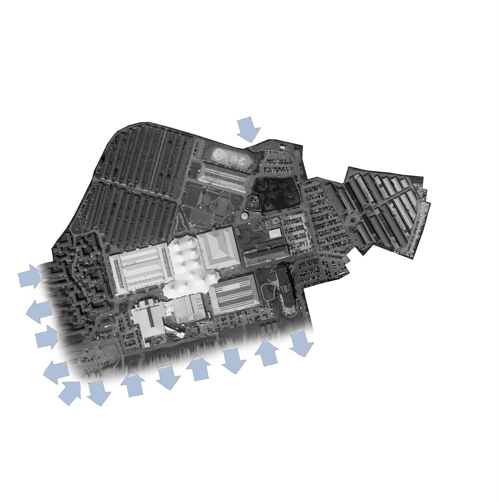
Butlin's has long been an isolated 'city' within the town, a self contained community. Permeating Butlins' hard barrier will create a connection with the town. The potential of the southern boundary shared with the promenade has been neglected by the resort. Its metal spiked fence implies a negative relationship with the beach and the town. 
The resort is located in the centre of the town and form stronger connections with its context. The map shows the resorts location and size within the town. It is a small self sufficient city. A key strategy is to explore the blurring of the boundary the resort has with the town and the promenade. Blending the urban with the natural can allow economic, spatial and healthy reconnections.
Butlin's bleeds with the town


Monday, 15 November 2010

The Pleasure Beach 기쁨 비치

The second 'beach' like area of Seoul, after the Han River is Wolmido, a pleasure beach. A liberating place unfound in central Seoul, offering cheap tacky fun. The promenade resembles a prison like space, where street furniture clutters and restricts views out to the sea. A ride on the monorail would offer a better elevated vantage point, but what about the pedestrian?

In high season the small island is over run with people and cars, the second image looks to visualise this automobile bombardment.


Tuesday, 26 October 2010

Seoul & The Sea

This drawing looks at Seoul's urban growth towards the Yellow Sea to the West of the city. The seaport of Incheon is the nearest city to Seoul and has a population of 2.7 million making it South Koreas third largest metropolis. The transport connections between the two cities make the travel time between the two centres not much more than an hour. Our location is flagged in red which represents the KNUA campus.


Wednesday, 20 October 2010

A Gift 2D Seoul 2 차원의 선물 서울

Rosa managed to befriend a very nice guy in the architecture department who passed on a gift of indescribable richness and complexity, the whole of Seoul in 1.72 giga bytes. The map of seoul shows the city tiled out of individual CAD files. A great gift.

Monday, 18 October 2010

1| Hangang City Park 하천 도시 공원

Our first day in Seoul began with a cycle ride along the Hangang (River). A huge entity that powers through the city. The edge condition is mind blowing... transport infrastructure passes along the bank and is pierced every now and then by the sweeping bridges. The monolithic character speaks of a cold and brutal urban reality, but the Han Renaissance project has worked wonders with the sheltered spaces below providing a park the length of the city. Planting, outdoor gyms, cycle and hiking lanes create a complex space where the citizens can escape. The Hangang park is an underworld with the noise, pollution and congestion left elevated above. A strange utilitarian beauty is embodied in the concrete forms and provide a tectonic ensemble of vertical columns and sweeping horizontal platforms. A calmness has been created in these spaces through planting which helps soften the menacing infrastructure. 

Bike rental was 'service', which was the stewards way of saying free, this meant that anyone could enjoy the entire rivers edge. We cycled a few kilometres in 3 hours coming across many activities, which included fishing, sailing, power walking, basketball, amphitheaters of varying sizes, badminton courts, picnic zones demarcated on the concrete floor, gym machines, volleyball courts and football pitches. River activities were prevalent, with people wind-surfing, sailing and catching small water ferries, which embark from a floating station. The park also included a boat yard where pleasure craft and fishing boats were stored. The amount of activity surprised and excited me, as it showed that the river is beginning to be loved and enjoyed. The renaissance project has created a unique environment a park the length of the city, which the citizens are taking full advantage of.
The Han River Renaissance Project
(Source: Seoul Met Gov, 2008a, 57,93)


'The Han River now belongs largely to the Republic of Korea, or South Korea, with its effluence in the Yellow Sea a few nautical miles from North Korea (though some of the river's tributaries are in North Korea). During the first few decades of South Korea's existence the Han River became a byword for pollution, as burgeoning industry and an impoverished populace used it as a convenient spillway for industrial and urban refuse. Though it no longer plays a central role in commerce or transportation it is a prime fixture in the life of the South Korean capital and in the last decade has become the focus of government sponsored environmental efforts to clean it up and transform it into an ecological jewel of the capital. During the 1988 Summer Olympics in Seoul, the Han River was the site of the Olympic rowing regatta.' (http://en.wikipedia.org/wiki/Han_River_(Korea)

The World Is Not Enough

With my journey now underway I would like to talk about my Dubai experience. This city and it's culture should be so different and unrecognizable in so many ways and some parts are, but unfortunately the huge malls and skyscrapers that are so dominant are good examples of 'non-places' of our supermodern society (Marc Auge). The 'Old areas Bastakiah and Diera resembled a traditional city with their narrow streets and small souks (markets). But an overwhelming sense of sameness and banality was felt in the new areas. It is clear a rich culture can be diluted by the perils of being a global destination. The array of malls all sporting the same global brands was expected and hit home the gaudy and sickly state of our capitalist appetite for consuming. Dubai has with its linear character monopolised the excess of space by building along the coast, but why go so high with so much land? I wondered what forces are at play with regard to density or land prices? And I have to admit it just left me baffled, which means I have to take it for what it is 'a playground vision being fulfilled'. A strange ugliness pervades a place built on money and not on the personal needs and relationships of its citizens. 
Dubai has a strained relationship with water and is a good example of a dislocated society. Water is used extensively as a method of passively cooling exterior spaces and this is a harmonious and historic technique. But when a city survives solely by the energy intense method of desalinating seawater and air conditioning spaces to keep the city functioning, it does beg the question, is this extremely short sighted in the current global environmental climate? I was surprised by the amount of green planting and wondered how much water it must take to keep the city artificially and aesthetically pleasing. This need to perform becomes most evident with the 'Burj Khallifa' water show that takes place every evening at the foot of the 830m high worlds tallest building. It was incredible and all I could ask myself was how much? and at what cost? 


The city's coast with the sea breeze and cooling ocean is an Oasis, but has been pillaged by private owners. The land mass is not enough and new formations are being created off the coast, with new beaches and Islands sculpted into mad desires. Land reclamation has its ecological issues and the flows and movement of stagnating water is a key problem. Acting God and creating a 'New World', and the 'Universe' highlight the superficiality of the place. I was intrigued to notice a lake of development on these creations. The World was desolate, no sign of any civilisation, has the global financial crisis doomed this dream. It's fascinating to contemplate the scale of engineering achievements that have taken place in this one city, but I find the quality and thoughtfulness of the designs somewhat doesn't match. The city visually entertains on all the scales and that is a interesting point of departure for the rest of my research. I will return to see if this architectural disneyland will survive or adapt to the strains not to far away.


An article titled the 'The Mad Experiment' succinctly talks about some of the above issues:
http://www.newsweek.com/2008/06/28/the-mad-experiment.html


Non-Places: Introduction to an Anthropology of Supermodernity (1995),  Marc Auge

Monday, 4 October 2010

Water Scarcity!

80% of the worlds population lives in areas where a fresh water supply is not secure. The result can be seen in a map that plots the composite threat to human water security and to biodiversity in squares 50km by 50km (30 miles by 30 miles) across the world. "What we've done is to take a very dispassionate look at the facts on the ground - what is going on with respect to humanity's water security and what the infrastructure that's been thrown at this problem does to the natural world," said study leader Charles Vorosmarty from the City College of New York. What we're able to outline is a planet-wide pattern of threat, despite the trillions of dollars worth of engineering palliatives that have totally reconfigured the threat landscape." The "trillions of dollars" of investment are represented by the dams, canals, aqueducts, and pipelines that have been used throughout the developed world to safeguard drinking water supplies.
Their impact on the global picture is striking.


Natural


Managed


Related stories from the BBC
http://www.bbc.co.uk/news/science-environment-11435522
http://news.bbc.co.uk/1/hi/sci/tech/7865603.stm
http://news.bbc.co.uk/1/hi/sci/tech/8399036.stm

Sunday, 26 September 2010

Tidal Rhythms

The gravitational forces exerted by our Moon, Sun and the rotation of the Earth create a constant changing landscape where water meets rock. The mapping of tidal movements can take many interesting forms. Our infrastructures and environments are constantly marked by this celestial condition. From high to low tide our thresholds are eroded, destroyed, flooded, scattered with debris and marked with the stories of our physical world. The passing of time is seen as the water oscillates on the coasts and banks of our habitats. Our architectures have the ability to have ever changing dialogues with the environment and with our universe.

NASA/GSFC - M2 Tidal constituent, Amplitude is indicated by colour. Mapping of global tidal movements.

Wednesday, 1 September 2010

A Powerful Threshold


Aerial view of Bognor Regis, with the Butlins Holiday camp just off centre. Image approx 10km across with the green belt highlighted beneath at a smaller scale. The image shows the towns relationship and threshold with the water body of the English Channel.